



Start at the top
This is a guest post by David Clubb, Independent Chair of the Taff Catchment Partnership.
This blog post is based on the evidence that supports greater activity at the top of a catchment, in order to produce bigger benefits throughout – and particularly at the bottom. However it comes with caveats….read on to follow my reasoning!
The source
The Taff begins twice. The Taf Fawr begins just below Corn Du, whilst the Taf Fechan has its origin below Pen y Fan. They meet at Merthyr, and are joined by the Bargoed Taf at Quakers Yard, the Cynon at Abercynon, and the Rhondda at Pontypridd. The river runs 67km from Merthyr to the Bay at Cardiff.
It’s important to think about the source, because often we think about the results, particularly when bad things happen. Floods in Pontypridd, pollution in Cardiff Bay….these outcomes cannot be solved by action just in Pontypridd and Cardiff. The whole point of a catchment approach is to take a holistic view, allocating resources where it makes best operational sense, and not where it’s necessarily the most visible.
Water, sediment, nutrients; they join the water courses and flow downwards. Building walls along the banks of the river will treat the symptoms, but not the cause. Here’s the case for improving outcomes for everybody in the catchment by focusing on the uplands.
The maths of the headwaters
Headwaters are the source of a stream or river. They are, naturally, the least visible part of a river network (who, looking at the Taff from Cardiff Bridge, thinks of the uplands beyond Merthyr?), but small streams make up a high proportion of channel length of any river network, and headwater catchments account for more than 2/3 of the drainage area. So – counterintuitively – most of the Taff is up ‘on the top’ rather than in the valley.
Small watercourses are disproportionately affected by what happens on their banks, because the ratio of edge (stream bank, river bank) to water surface area is much higher than for large rivers. If you don’t believe me, try stepping over a stream, and then over the Taff as it enters Cardiff Bay. That distinction is important because shading, pollution, leaf litter, bank condition and land management all have more influence per hectare in the headwaters than they do in the main river.
Hydrological processes in headwater catchments govern recharge, flow paths and residence times through the whole landscape, and the coupling of hydrology and biogeochemistry upstream determines the chemical form and timing of what eventually reaches downstream waters. In other words; the top of the catchment is fundamental to the health and resilience of the whole catchment.
Nature’s role in slowing the flow
There are some useful tools available to understand what’s happening in our river systems. One of these is a hydrograph, which plots the depth of the river against time.

The shape of the hydrograph across the Taff is determined mostly by the uplands, simply because that’s where the vast majority of the land area of the catchment lies. So if one of the main objectives for the Partnership is to reduce the impact of flooding in the towns and villages, the majority of our focus must be on the uplands and headwaters.
The evidence for peatland restoration as flood management has matured significantly. Catchment-scale modelling of peatland restoration above Glossop found that re-establishing Sphagnum (moss) in dammed erosion gullies across roughly 40% of the catchment produced a >95% likelihood of reducing peak flows by more than 5%, for storms with return periods of 10 years, right up to a one in a 1000 year storm.
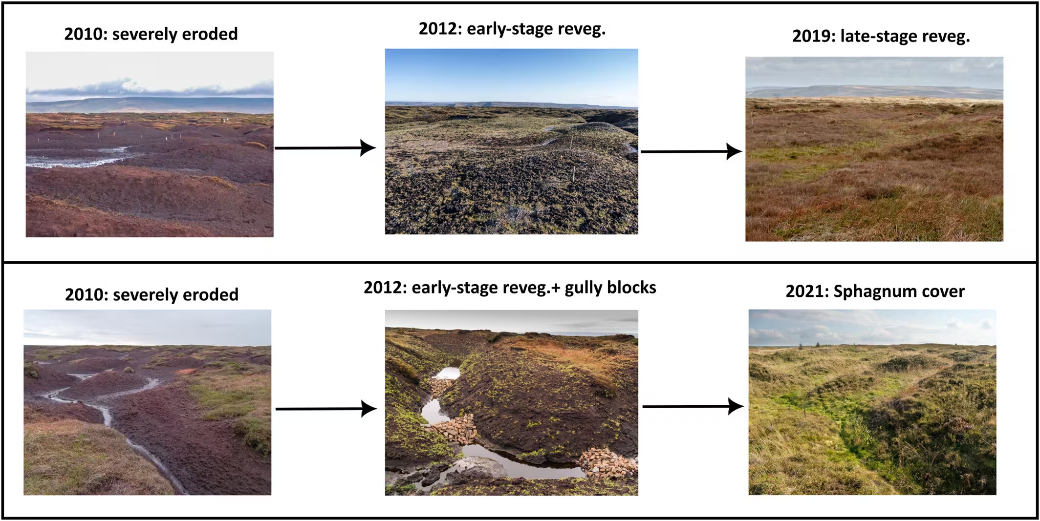
Contrary to popular understanding, it’s not the ‘spongelike’ nature of restored uplands that maintains water, it’s the roughness of the surface that slows down the water flow.
The three main ways that an upland intervention can reduce a downstream flood peak are:
- Store water during the event
- Generate runoff more slowly, or
- Slow the water down once it is moving.
Peat does almost nothing to store additional water during rainfall. In an intact peatland the water table sits within a few centimetres of the surface, so there is very little capacity left to absorb anything; significant rainfall pushes the water table straight to the surface and generates saturation-excess overland flow.
Real storage in peatlands is therefore surface storage; water collecting in depressions, hollows, pool-and-hummock microtopography and the pools formed behind gully and ditch blocks. Degraded peat has lost those features. However, even this storage has a limit. Once it’s filled over continuous wet weather, or in a severe storm, there is no further capacity.
That’s when the surface roughness comes into play. Storm runoff from blanket peat is dominated by overland flow, the rate at which water reaches the stream is largely a function of surface cover. Plot-scale experiments by Holden and colleagues measured this directly: overland flow travels roughly ten times faster across bare peat than across Sphagnum. Change the surface, and you change the delivery time to the watercourse of every drop that falls on it.
A before-after-control-intervention experiment in the Ashop catchment in the Peak District provides further evidence. Revegetating bare peat cut peak flows by 27% and more than doubled hydrograph lag time. Adding gully blocking reduced peaks by a further 24% and extended lag by a further 94%. The critical detail is that the storm runoff coefficient (the proportion of rainfall leaving the catchment during the storm) stayed the same; the peak fell purely because the water arrived more slowly and spread out.
So the reason Sphagnum re-establishment scores so highly in upland water management is not because Sphagnum stores more water, but because Sphagnum is so ‘rough’ to the flow of water.
Modelling of an 84 km² Yorkshire catchment found that reintroducing Sphagnum to the 5.8% of the catchment that was bare peat cut the 1-in-10-year flood peak by 5.2%; and planting the same area in riparian zones instead produced a roughly 15% reduction.
From flood to fire
What makes the upland case overwhelming, though, isn’t just in mitigating flooding. It’s that restoring the uplands carries out multiple benefits, including acting as a firebreak in our increasingly wildfire-prone environment.
In April 2025, wildfires burned across mid Wales. NRW’s assessment of the rewetted peatland at Llyn Gorast in Tywi Forest, restored in 2023 with dams and contour bunds, found that the wet pools and Sphagnum regrowth appeared to have acted as a firebreak, limiting the fire’s spread, while an adjacent site awaiting restoration was burned. The same happened in a part of the Elan Valley in 2026. Healthy Sphagnum holds many times its own weight in water; degraded peat colonised by Molinia is highly flammable when dry.
The 2026 fire season has been the most severe on record in Britain. By 10 August, more than 23,000 hectares had burned across the UK, with 72 individual fires larger than 30 hectares. Wales has broken all previous records (and not in a good way!).
In late April, fires in the Elan Valley burned over 8,000 hectares and took six days and helicopter support to control, with a smoke plume visible from space stretching more than 50 km. On 29 April a wildfire started in Bannau Brycheiniog National Park and spread across roughly 20 km², burning forest, peat and grassland and closing the A470. In July, a fire on the hillside near Blaenavon burned for over three weeks and required army assistance. Indeed, it was a topic of conversation in Ross on Wye, many miles away, where I was visiting with my family at the time.
In August, crews were still working the Llangynidr Reservoir moorland fire, with NRW and the National Park Authority already assessing what restoration would be needed afterwards.
Upland nature restoration could prove to be an essential component of our infrastructure resilience. In the video above, you can see high voltage electricity lines over the smouldering peat. Houses were burned to the ground; roads made impassable by smoke and fire risk. The relatively modest costs of restoring our uplands are surely an integral part of Wales’ future resilience to climate change.
Fire is now also a flood risk. Once peat and soil burn they stop functioning as the holder of water in the high ground which raises flood risk downstream. Fire and flood are not two separate events or systems, but a cycle, with one effecting the other. A bad August in the headwaters of the Taf Fawr and Taf Fechan is not only a carbon and biodiversity disaster, but it also degrades the storage capacity that stands between autumn storms and the communities in the valleys.
Peatlands cover only around 4% of Wales but hold roughly 30% of its land carbon. Approximately 90% of Welsh peatland is currently in a damaged condition. With summer rainfall in Wales projected to fall by around 15% by the 2050s, the uplands assets that can offer mitigation for our floods are the same assets that can mitigate our droughts and our fires.
Learning from Stroud
We’re fortunate to have a relatively local exemplar of how to restore uplands, with Stroud Discrict Council being widely recognised at carrying out good practice in nature-based solutions.
The Stroud Valleys Natural Flood Management project has been running since 2014, covering the River Frome and its tributaries. The parallels with the Taff are strong. Stroud flooded badly in 2007 and has seen flooding somewhere in the valleys every year since. The Environment Agency designated the Slad and Nailsworth valleys as rapid response catchments, the same ‘flashy’, steep-sided behaviour NRW describes in the Taff. Given what I’ve outlined above, the communities and authorities there reached a conclusion we can recognise: the upper Frome and its tributaries are not suited to hard engineered solutions, partly because of the physical nature of the catchment, partly because of where the at-risk properties sit, and partly because of the heritage and landscape value of the valleys.
The Stroud approach is exactly the one this post makes the case for, namely a wide range of measures dispersed around the headwaters that cumulatively slow flows, rather than a single large structure near the properties at risk. Much of it is large woody debris, using wood sourced from ordinary woodland thinning immediately streamside, which makes it both cheap and repeatable. Their own technical framing is that a large number of debris dams over a short stretch can be more effective than one big structure.
After a decade of on-the-ground action, the results are:
- Over 1,300 interventions across the wider Frome catchment
- 40% of the catchment now draining through Natural Flood Management (NFM) features
- 50 local land managers and contractors working together on delivery
- Over 1,000 people engaged through local and national groups
- A monitoring network established specifically to evidence NFM performance
Four lessons from Stroud can be applied to our approach in the Taff:
- Much of the upper Taff catchment has the same combination of steep sides, scattered at-risk property and heritage landscape that ruled out conventional defences in Stroud. That constraint is exactly what makes distributed upstream work the most practical option
- Nearly 1,500 low-cost interventions delivered with local land managers is a fundamentally different funding and delivery proposition to a capital scheme. It is also far more compatible with blended finance and with a partnership model where no single organisation holds the whole budget. Having local farmers and land managers as the delivery agents builds support for the work and keeps money within local communities
- The project exists because the Severn and Wye Regional Flood and Coastal Committee funded a project officer, employed by the district council under a collaborative agreement with the county council and the Environment Agency. Twelve years of continuity in one post is doing an enormous amount of the work. The academic literature on catchment governance is unambiguous that the coordinator role is the single most critical and most chronically underfunded element, and Stroud is a live demonstration of what funding it properly can achieve.
- Any before-and-after comparison is only possible for Stroud because gauges were already collecting data before the works began. If we want to be able to say anything credible about the Taff in 2040, the baseline has to be established at the outset.
Invaders into the Taff
Another issue facing the Taff is invasive species, with Himalayan Balsam and Japanese Knotweed endemic across large areas.
Whilst Japanese Knotweed requires specialist training and equipment to control, Himalayan Balsam can be managed by volunteers – and ripping out the plants is a fun and satisfying way to spend some time.

Himalayan balsam is an annual, which means that next year’s ‘crop’ is dependent entirely upon this year’s seed. These seeds float, which is why watercourses are so valuable to the plant, and also why volunteer efforts downstream are only ever effective for that year, and for that area of riverbank and downstream.
The Scottish Invasive Species Initiative puts it plainly: control work needs to start with the most upstream plants in a catchment, because treating plants downstream first is futile; seed from upstream plants washes down and re-infests cleared ground. Seed remains viable for roughly 18 months to three years, so each river bank area needs two or three consecutive seasons to exhaust the seed bank.
The operational conclusion is that a volunteer day spent clearing balsam from a downstream reach with an untreated population above it buys a year, and commits you to the same day next year, indefinitely. The same day spent at the top of a sub-catchment buys ground that stays clear, and every subsequent year’s work starts further down a shrinking front.
That distinction matters enormously for a partnership that depends on volunteers and community groups. Asking people to give up Saturdays is asking a lot. Asking them to give up Saturdays for work that will visibly be undone is potentially causing them to lose faith. Sequencing top-down is technically correct and the most efficient use of resource.
The same directional logic applies to giant hogweed, to knotweed fragments in flood debris, and to biosecurity for aquatic invasives more broadly. Wherever water is the vector, upstream is the priority.
In practical terms for the Taff, the ‘top’ means different things depending on the headwaters, so in practice, a catchment-wide balsam map with a coordinated push from the top of each sub-catchment would be the most practical approach to removing these invasive species.
Water quality, and ecology
The Pontsticill catchment on the Taf Fechan covers a little over 16 km² and supplies water to more than 160,000 properties across Merthyr and south east Wales. Dŵr Cymru’s Bannau Brycheiniog Mega-Catchment programme exists precisely because tackling water quality issues at source reduces the chemicals and energy needed at the treatment works downstream.
Rising colour and dissolved organic carbon from drained and degraded upland peat is expensive to remove: it increases coagulant demand, produces more sludge, and reduces disinfectant efficacy. United Utilities’ Sustainable Catchment Management Programme invested £10.6m across 27,000 hectares in its first phase and £11.6m in its second, on the straightforward business logic that restoring the hydrological function of upland peat is cheaper than building and running the capital plant needed improve water quality at the water distribution end.
Headwaters contribute disproportionately to biodiversity at the scale of the whole river network. They also provide the cool water that downstream species retreat to when the main river becomes uninhabitable.
Enhancing shade to hold water temperature down via riparian woodlands is far more effective in small tributaries than in the main stem, where shade plays only a minor role. If we want the Taff to still hold salmon, sewin and eel in 2100, the interventions that make a measurable difference to thermal regime are in the headwaters.
Where ‘start at the top’ doesn’t work
Starting at the top makes a lot of sense for many aspects of river management, but there’s a nuance to that approach.
- For migratory animals such as salmon the sequence is inverted – there’s no point carrying developing fish passes at Merthyr if previous obstacles lower down haven’t been resolved
- Combined sewer overflows, urban diffuse pollution, culverted watercourses, property-level resilience and community flood plans are all concentrated where the population is, namely in the middle and lower catchment. Although revitalising the uplands will result in the biggest long-term wins, we can’t expect that work to be undertaken in isolation from the additional engineering and education that will protect people in the valley floors in the coming years
- Consent is needed from the communities impacted by the issues presented by rivers. A programme that is entirely invisible to the communities flooded in 2020 will not hold political or public support long enough to deliver, however good its hydrological outcomes. Visible downstream activity is necessary in order to ‘buy’ the decades of long-term programme in the uplands
So it turns out ‘Start at the Top’ is too simplistic; it should be ‘start at the top’ for downstream issues, ‘start at the bottom’ for upstream issues’, and ‘start everywhere’ when it comes to building trust with the communities of the Taff catchment.
Final thoughts
Here’s some thoughts about how the Partnership might want to proceed.
- Map the source areas to understand what’s happening across the headwaters, common land, institutional -held land and private landowners
- Sequence any invasive species removal work by sub-catchment, and from the top down, for three consecutive years per area
- Monitor from the top, starting now. Any work carried out to attenuate water flows downstream will only be evidenced if we have a convincing baseline throughout the catchment
- Wildfire and flood risk are two sides of the same coin. Restoration work after this summer’s fires in and around Bannau Brycheiniog is basically upland flood storage work under another name, and should be planned, funded and monitored as such.
Cover image courtesy of Mark Grafton . The views expressed here are of David Clubb, Independent Chair of the Taff Catchment Partnership.